

Feeling hot, hot, hot
Near record temperatures for Wales and Northern Ireland, tinder dry terrain in Greater Manchester and Norfolk due to a jet-tream out of its normal position means two things: 1. keep yourself hydrated when out on the hill 2. feel sorry for those whom booked an early summer break to the Mediterranean where they have our clouds and rain! HYDRATE, HYDRATE, HYDRATE! Given the weather experienced in Wales, where I have spent the past week, the importance of hydration came to the fo


Is 'classic' an over-used word?
Classic cars, classic design, a timeless classic, the list goes on. Given a definition of 'an outstanding example of a particular style; something of lasting worth or with a timeless quality; of the first or highest quality, class, or rank' one could easily argue that usage is overdone in a world of modern, sophisticated, and omnipresent marketing. One could also argue that some things do stand up to the test of time and pass into lore, become a benchmark, or inspire future a


Monkey Weekend
A few years ago, I reached the summit of Western Europe with one of my best mates. We self-guided, we were inexperienced, we were naïve, and we wanted an adventure. On that trip I made a mistake that could have cost both of us our lives. It was a little stumble that has been the greatest lesson of my Mountaineering life. Fighting Demons This weekend, seven years later, I returned. I was asked by my great friend Edward Taylor if I fancied helping him climb Mont Blanc in his 30


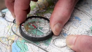
getting one's bearings
Having fixed your position at a particular grid reference on your map and having discerned the difference between your orienting lines and your orienting arrow on your compass, where is that you wish to go and how might you get there? Are you looking for a sunny spot out of the wind for a lunch break, or trying to find your way back to your car or tent? Either way, you need an objective or target location to navigate toward from your current position. Firstly, set your map -


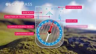
'we the globe can compass soon ...'
Very simple things are compasses, not at all like Shakespeare's plays, a bit of plastic with a needle that always points north. Really, that's about the size of it. Needle. North. Pointedly not when located next to your smartphone or leatherman though, they make strange bedfellows. It's the what you have to do with your compass that gets a bit tricky, especially when the pressure is on. And yet, as with most things, practice makes perfect, getting it out of your bag and using


what on earth is an easting?
There are loads of different types of maps but each has one thing in common: They all have grid of squares overlying the topographical features being mapped in any given location. We will focus on the Ordnance Survey of Great Britain's maps and their British Grid (BG) system, where each square drawn in blue lines (the map's grid) represents a one square kilometre area. The map's grid lines clearly run top to bottom, these are the 'eastings' because they divide the map vertica

why are there squares on maps?
Maps come in varying sizes, usually too large and doing its best to rip itself from your hands on a windy day, and they come in varying scales, usually giving seemingly insufficient detail or confusingly too much. Nevertheless what all maps have in common is a printed overlay of squares, the 'grid', each containing the detail being mapped for one square kilometre on a typical hiking map. Here, Chris Townsend from the British Mountaineering Council will take you through the pr


Dave's favourite mountain
Thinking skywards I remember the foothills of the Himalaya where I lived in my late teens, far higher than I have ever ventured since, I remember the hot and sticky journeys and being scared senseless by the terrible driving and the wrecks of colourful trucks strewn across the subtropical jungle. One night I was taken in an impossibly old Land Rover by a Gurkha friend to Tiger Point a place to see Kangchenjunga at day break, a turning point in my young life. There is also my