Maps come in varying sizes, usually too large and doing its best to rip itself from your hands on a windy day, and they come in varying scales, usually giving seemingly insufficient detail or confusingly too much.
Nevertheless what all maps have in common is a printed overlay of squares, the ‘grid’, each containing the detail being mapped for one square kilometre on a typical hiking map.
Here, Chris Townsend from the British Mountaineering Council will take you through the practicalities of establishing a ‘grid reference’ from a map should you need to work out or share an exact location.
History
Maps have been in use in the UK for political, military, or other uses for centuries and they became quite the fashionable thing in Victorian times, with all kinds of public agencies and private individuals producing their own to various levels of detail and scales. The 1-inch to 3-inch chains scale being one of the most widely used*.
It was as late as 1919 when a seminal thought occurred ‘a National Grid should be superimposed on all large scale plans and on smaller scale maps, to provide one reference system for the maps of the whole country‘ and the first practical steps were taken by the Ordnance Survey to provide one version of the truth for the whole of Great Britain and its territorial waters. The current ‘British Grid’ (BG) was the result.
Using the Squares

At their largest the BG grid squares have sides representing 500km and each is assigned a letter running from A to Z, but missing out the letter I. This has the twin benefits of avoiding potential confusion with the number 1 and of neatly making 25 grid squares in a 5 x 5 layout. A genius move making things very much the easier to deal with, imagine the faff of having 26 squares in this and the subsequent sub-division.
Each 500km grid square is sub-divided into smaller squares with sides 100km that are themselves each given a letter for identification and used sequentially together with the 500km letter to define an area.

Not all of the 100km squares are of practical use for ‘topography’ (a map of physical features of an area) because there is nothing there but sea.
Take a look at grid squares NE and TB on the diagram, nothing but sea to see there. OK so there might be a small island in there somewhere but it is hardly going to be big seller for the Ordnance Survey to produce a map for it, so they don’t. The Admiralty’s charts department does however, should you be so inclined toward messing around in boats.
So far so good should you wish to know where Cornwall sits in the British Grid (Grid Reference: SW), but further detail is required for practical use by mountaineers.
Zooming In

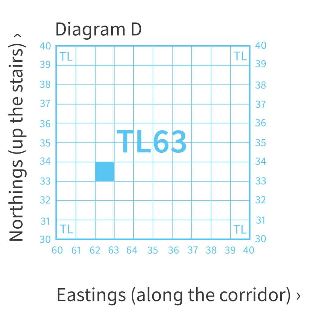
Accordingly, the 100km lettered squares – NH, SW, TL etc. – are broken down into 10 intervals each denoting a square with a side of 10km. These are assigned numbers 0 – 9, rather than letters, in order that a point of reference could be given clearly by a combination of letters and numbers.
Diagram D shows the ‘two digit Grid Reference’ TL63 and it refers to a 100 square kilometre area of Essex lying East of Saffron Walden and South of Haverhill. Not of much use to a person on foot!

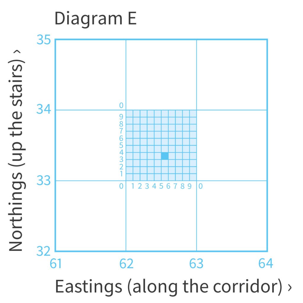
Helpfully, the grid can be further sub-divided by 10 again. Diagram E’s light blue shaded square has a ‘4 digit Grid Reference’ of TL 62 33. It relates to 1 square kilometre area NNE of the village of Thaxted containing fields and a wood.
This level of detail may be sufficient to indicate a general location for a meeting point, but are you North or South of the woods? If you wished to indicate a more precise location then the grid can be sub-divided down again to 10m and again to 1m intervals.
Diagram E shows both our TL 62 33 area of fields and woods highlighted, plus another smaller dark blue shaded square with a ‘6 digit Grid Reference’ of TL 625 333 within it.
This 6 digit grid reference is ‘to the nearest 100m’ level of detail and is about as accurate as one can be with an ordinary map and compass. TL 625 333 would place you on the southern boundary fence of the wood, north of a place called Spriggs and 100m east of the footpath. Informing someone of this 6 digit level of detail would make you much easier to find.
Even greater detail is, of course, possible. An 8 digit grid reference ‘to the nearest 10m’ can guessed at or be found with smaller scale orienteering maps and with electronic GPS equipment (below this their inherent accuracy tolerances will not currently go despite what it says on the screen). 10 digit grid references go further still, to the nearest 1m, as is possible with the tiny scale survey maps used by the Land Registry and local councils.
So, why are there squares on a map?
The answer to the question then is that the squares on a map allow a method by which you can pinpoint your location.
It follows that small ‘features’ – summits, crags, rivers and bridges, pubs – can be found on a mountaineering map, for which a ‘6 digit British Grid Reference’ can be determined, and these can be shared if you need to meet somebody or have somebody meet (rescue!) you anywhere in Great Britain.
and we’re done 🙂 Or are we? Knowing where you are is only the beginning. Knowing where you are going and how to get there, or where you have come from and how to get back there, relates to all the good stuff about ‘compasses’ and ‘bearings’ that can be found in our other blog posts.
See you out on the hill sometime.


