
There are loads of different types of maps but each has one thing in common: They all have grid of squares overlying the topographical features being mapped in any given location.
We will focus on the Ordnance Survey of Great Britain’s maps and their British Grid (BG) system, where each square drawn in blue lines (the map’s grid) represents a one square kilometre area.
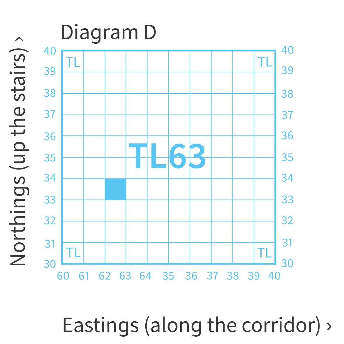
The map’s grid lines clearly run top to bottom, these are the ‘eastings’ because they divide the map vertically and moving from one to the other would mean moving eastwards or westwards.
Similarly, the grid lines running from side to side are the ‘northings’ because they divide the map horizontally and moving from one to the other would mean moving northwards or southwards.
Both sets of lines have numbers in matching blue type next to them at the edge of the map.
After reading about Grid References earlier, we know we need these numbers to locate ourselves, but how do you remember which ones are which and which come first in a grid reference e.g. TL 625 333?
One way to think about it is alphabetically, E comes before N in the English alphabet and so we quote the easting numbers before the northing numbers.
Another way is to use the delightful old mnemonic phrase describing a child going to bed, whereby they go ‘along the corridor’ before going ‘up the stairs’ to their room.
Whichever way you come to remember your easting from your northing, the order in which you quote grid reference numbers is critical.
Determining a grid reference
Here you can watch as the Ordnance Survey has Steve Backshall take you through the process of determining a 4 digit grid reference, explaining the easting from the northing along the way.
Origins of use
The term ‘northing’ was first recorded as used by Isaac Hayes addressing the New York Geographical & Statistical Society in 1861 and its implied derivative ‘easting’ followed shortly after. Both have been in use since, but why?
Simply because it proved a clear way to describe a concept common to all mapping applications. A British Grid grid reference* is given by a combination of letters and number pairs or, more commonly for mountaineers, triples e.g. TL 625 333. The letters denote the general area that your map sheet covers, and the numbers are used to denote a more precise location within that area.
It is imperative that the order in which the numbers are plotted and then communicated is the correct way around. Get your eastings and northings mixed up and you can be thought to be tens of kilometers away from where you really are. Thankfully, when working the British Grid with its two-letter prefix it at least denotes which bit of the country you are in.
So, we always quote our British Grid sheet letters (e.g. TL) and ALWAYS run along the corridor (e.g. eastings 625) before heading up the stairs (e.g. northings 333). Always. That’s always always and not the sometimes always that happens after a few pints. Got it? Good.
Practical Use and Scale
It may prove useful to think of a grid reference’s eastings and northings in terms of getting to work.
If you work in The Gherkin, in London, then TQ 33 80 will be the area of the city you commute to, as it defines a 1km x 1km square, whilst TQ 333 812 defines the smaller 100m x 100m square where your office building is, and the most precise TQ 33308 81254 gives the point reference of your desk!
As an aide-memoire, if in your given grid reference there are:
- No digits: the Grid Reference is the whole 100km x 100km square
- 2 digits: the Easting and Northing are each in units of 10km;
- 4 digits: the Easting and Northing are each in units of 1km;
- 6 digits: the Easting and Northing are each in units of 100m;
- 8 digits: the Easting and Northing are each in units of 10m;
- 10 digits: the Easting and Northing are each in units of 1m.
The final word goes to Backshall determining the eastings and northings making up a 6 figure grid reference …
You know where you are. You can tell me where you are. Awesome! Now where you are going and how do you get there? Have a gander at the ‘compasses’ and ‘bearings’ blog posts 🙂
*other grid references are used around the world! However; for our ease and consistency we’ll stick with British Grid format and ignore UTM and the rest for now. It is enough to know that the same ‘easting first, northing second’ principle applies equally to any map grid notation around the world.