Search Results
26 items found for ""
- Bring back Winter!
“We feel cold, but we don’t mind it, because we will not come to harm. And if we wrapped up against the cold, we wouldn’t feel other things, like the bright tingle of the stars, or the music of the Aurora, or best of all the silky feeling of moonlight on our skin. It’s worth being cold for that.” - Philip Pullman, Northern Lights Red Skye The second of the two Skye Trail trips this year was hot. Very hot! It was also exceptionally dry. Especially for the West Coast of Scotland - an area renownd for being wet! - which was basking in sunshine whilst most of England was under grey clouds! The boggy ground turned crispy and hiking on this usually 'avoid at all cost' terrain was like hiking in the African Savannah - every step crunching underfoot. Something strange was happening... This was not normal... Surely this weather won't last long... But I was just about to leave The UK to distant lands, far, far away. I was going back to the cold, baron world of the High Mountains! I didn't need to concern myself with this heat any more... Standard UK summer would return before I got back. It will? Won't it? The burning sun continued... I returned from successful summits of Mont Blanc (French Alps) and Elbrus (Russian Caucasus) to heat in The UK so unbearable that I had to leave London almost as soon as I had arrived! I had to get away from the crowded, baking city. I had to get to my happy place. I went to The Lake District to find solace (coolness?) in the mountains. But it was still hot! - It hadn't rained for weeks and the hills had turned a pale, yellowy-green colour. The lakes were warm and the valleys were filled with a heat I'd never experienced in the UK mountains before... There was only one thing for it... I packed my rucksack and headed high to look for a breeze to cool me down. I decided to bivvy on mountain peaks more through necessity, than pleasure (not that it wasn't pleasurable :) Four nights I spent up high in The Lake District (with just one night in Ambleside after a friend visited the area to climb and insisted on going to a pub... Is there a cooling equivalent to the beer jacket? - I'm not sure but it was a great night! - A story for another time...) Four nights of solitude and a cool breeze... Finally, my frazzled brain could cool down... I could think again! Terrible Winter, Great Summer? You may have heard/read my ramblings about this past winter. It was absolutely glorious in it's intensity and longevity! There were some tough days with high wind and whiteouts, but those proved to be few and far between... In Between the majority of days of blue skies and beautiful white mountains... My winter in the bleakness of the Scottish mountains was possibly my favourite season I have ever experienced in my 29+ years [ahem] on this beautiful planet of ours. But, outside of my little mountain bubble, I heard of complaints. Complaints about the snow, complaints about the cold, complaints about the short days. I therefore believe that it is my prerogative to offer my own complaints about the weather... I want to complain about the heat, I want to complain about the drying rivers and lakes, I want to complain about the heat, I want to complain about the long days, I want to complain about the heat... If people can complain about the best winter we've had in many, many years; I can complain about the best summer we've also had in many, many years... (did I mention the heat?) Amazing Winter, HOT Summer! I will start with the landscape: We are a small island with such amazing variety of landscape that one would struggle to find anywhere else in the world with such diversity in such a small area! The winter mountains are transformed from a rainbow of colour in spring, summer and autumn, to a completely different black and white landscape in which few people dare to tread. Our beautiful little hills turn in to gnarly monsters and seem as inhospitable as many mountains around the world, much bigger in size... They become a new adventure playground and, with most people wrapped up at home, an area of solace away from the crowds. But where is the summer mountain colour that should be prevalent at this time of year? The hot, dry spring and summer has changed this colourful landscape to yellows and browns... And fires! There have been wild fires! Hot or Cold? Secondly, let me discuss hot versus cold... This is simple... When it is hot, we take layers off to cool down. There are only so many layers that we can remove before it becomes [apparently] "inappropriate". I reached that "inappropriate" layer when I was in The Lake District - I even went for a swim in a lake! - But I was still hot! - I couldn't get away from this heat! - The baked ground intensifies the heat and, at times, it's intolerable! In the winter, we do the opposite... We put layers on to warm up... We can put more and more layers on as it gets colder and colder... Our body heat is regulated easily and we can be outside, enjoying the crisp, cold days, feeling toasty warm, being hugged by our nice warm clothes! - Win! Shorter Days! What's with the loving of long days? - Ok, this is a tenuous complaint as I do enjoy those warm [not hot!] summer evenings, but I'd like to promote the advantage of the shorter days :) The main advantage for me is photography! - The best light for taking photos occurs around sunrise and sunset... Now, think of when the sun pokes its head over the horizon and tell me what sounds better: 1. Getting up at 9am to photograph sunrise and staying out until 4pm to photograph sunset before retiring to a remote pub, with roaring fire and hearty food, for the evening, or; 2. Getting up at 3am to photograph sunrise and waiting until 10pm for sunset then, by the time you get back to civilisation, the pubs are closed! No Complaints In reality, I love the diversity of weather our little island gives us. I love the seasons and the changes that occur in nature throughout the year. I just don't like the heat :) So much so, I have spent more time indoors, avoiding that hot sun, this past few days than I have for the rest of this past year combined! How have I taken my mind off the heat? I simply took my thoughts to winter... I was so engrossed in reminiscing in our recent winter that my excitement got the better of me and I started planning for next winter! (winter trip diary is now available by the way ;) This blog set out to complain about the summer, but it seems to have simply promoted winter. There's no value in being negative about something when you can be positive about something else! - No need to complain, just enjoy life... Enjoy Summer. Get Outside. Enjoy the British Landscape in all its glory (just hope for a bit of cloud cover once in a while ;) #Winterhiking #Mountaineering #Mountainbenefits #Mountainweather
- Feeling hot, hot, hot
Near record temperatures for Wales and Northern Ireland, tinder dry terrain in Greater Manchester and Norfolk due to a jet-tream out of its normal position means two things: 1. keep yourself hydrated when out on the hill 2. feel sorry for those whom booked an early summer break to the Mediterranean where they have our clouds and rain! HYDRATE, HYDRATE, HYDRATE! Given the weather experienced in Wales, where I have spent the past week, the importance of hydration came to the fore. Remaining adequately hydrated when on a long day in the sun is important not just for pure physical performance but for mental performance also. Your concentration and decision making are impaired as fluid levels drop below optimal, something to consider if you're off path taking a bearing, rock or scrambling a rocky ridge route. Fluidy top tips 1. Don't get worried and go mad with your water. Drinking too much is actually more dangerous than drinking too little; overly diluting your sodium levels causes organs to swell and can kill you! Very few people die of dehydration as it's effects are far more easily countermanded than its opposite condition. It's easy to get fluids in, much more difficult to get them out again. 2. Know where the water sources are on your planned route. Where are the watery bits on your route? Can you revise the plan to take in some likely spots where you can re-fill if needed, or even better have a paddle or a swim to cool off. Water considered for re-filling needs to be flowing and above the level of any nearby farms. If you have concerns then pack some purification tablets. They are cheap and weigh nothing. 3. Drink before you leave! At breakfast or an hour before you start out, sip your way slowly through half a litre of juice, squash, milk, or water as you choose. Once on your route ‘drink to thirst’ i.e. always have fluid available and drink when you feel thirsty throughout the day. On hot days in baking sunshine the best thing to drink is water with electrolytes and carbohydrates (posh names for salts and sugar), like those found in Powerade or Lucozade Sport or squash with an electrolyte tablet dissolved in it. The watery bit keeps you hydrated, the electrolytic bits replace those body salts lost through sweating, and the carbs replace the fuel burnt getting you up and down. 4. Check the colour of your pee! Anything darker than a straw coloured yellow means you need to be taking on more fluids. Note that, for me, sipping steadily through the day whilst on the move seems to reduce the total number of wee stops. As opposed to stopping and gulping half a litre and then needing the loo five minutes later. Have a great weekend in the sunshine! #scrambling #hillwalking #summer #hydration
- Is 'classic' an over-used word?
Classic cars, classic design, a timeless classic, the list goes on. Given a definition of 'an outstanding example of a particular style; something of lasting worth or with a timeless quality; of the first or highest quality, class, or rank' one could easily argue that usage is overdone in a world of modern, sophisticated, and omnipresent marketing. One could also argue that some things do stand up to the test of time and pass into lore, become a benchmark, or inspire future action. One such influence upon what was to follow was Steve Ashton's classic, in the fullest sense of the word, guidebook 'Scrambles in Snowdonia' the first of its kind to bridge the gap between rock climbing and a nice walk in the hills. Published in 1980, when scrambling wasn't even a thing to most, the book sold well enough to require three re-prints in the 80's. A second edition followed in 1992, which went through a further ten re-prints, the last being in 2013. The success of the second edition was in part due to the acceptance of scrambling as a legitimate mountain activity, mountaineers were (are?) a partisan and small c conservative lot, and mostly due to it being a very well thought out and well written book that told one exactly what one needed to know for a more exciting day on the hill without a ton of kit. Fast forward to 2018 and it would seem that even a classic requires a polish. Cicerone have released a third edition that includes all of the classic (that word again) routes that you will have heard or dreamed of including the Snowdon Horseshoe, North Ridge of Tryfan, Bristly Ridge and the Cneifion and Cyfrwy Arêtes. The new edition sees five routes dropped, no tears will be shed, and 16 new routes included as selected by the updaters. Only time will tell if the additions cut the mustard, but with 80 graded scrambles illustrated with photo topos to clamber over this you will be hard pushed to find anything to complain about for the cover price. A bargain at twice the price. #scrambling #Cicerone #books #routes #classicroutes #snowdonia #tryfan #glyders #carnedds
- Monkey Weekend
A few years ago, I reached the summit of Western Europe with one of my best mates. We self-guided, we were inexperienced, we were naïve, and we wanted an adventure. On that trip I made a mistake that could have cost both of us our lives. It was a little stumble that has been the greatest lesson of my Mountaineering life. Fighting Demons This weekend, seven years later, I returned. I was asked by my great friend Edward Taylor if I fancied helping him climb Mont Blanc in his 30th year and I jumped at this opportunity. Not only to head out on another expedition with a friend, but also to get that mistake monkey off my back. The bloody monkey that has been there for seven long years; I was going to walk the same route as previously, past “that drop” over the edge, how would I react when we arrived at the spot? The weather forecast brought the realisation that our acclimatisation and summit plans were scuppered. We were going to have to abort and head to a different playground in Switzerland instead. But then ... a weather window appeared ... we could still do it! It would be tough, but it was on! Mont Blanc Day 1: depart the road head at Les Houches and ascend 2,000m with full expedition packs over the 10 miles to Tête Rousse Refuge at 3,200m. Then, with no room at the inn, camp outside. Day 2: amble across the Grand Couloir and scramble 500m to the Goûter Refuge at 3,800m and stay there ready for summit day. But, ‘advanced booking is compulsory’ – yeah, OK ... Day 3: wake up at 1am, depart at 2am, reach summit at 6am, simples! All went well. I hiked past “the spot”. I acknowledged “the event”. No fear. No emotion. Just hiked. Phew! Onwards to the summit. And what a beautiful day it was! Having risen, of course, we then had to descend, and it was on the descent when the 'event' happened previously. However; this time around, I was safeguarding two people – we had allowed someone else onto our rope when his mate bailed – and I had to be diligent. I knew the risks having nearly been one of those statistics. For once, I was autocratic; “this is how you walk”, “this is what you do here”, “this is what happens when X/Y/Z”, all the time thinking that I will not let monkey time happen again. All went smoothly. All was great. Even if the 3,800m descent straight back to the car at Les Houches did hurt a bit. The most noteworthy things for me? How I felt and how I looked. Seven years ago, I just wanted to get off that hill. I was cold, I was anxious, my head was fuzzy, I was at my limit and I looked a mess, as you can probably tell from this photo taken at the time. This time around I was well organised, my head was clear, I was relaxed, and well inside my comfort zone. I wanted to spend the rest of the day on that summit. I loved it. Hey Monkey. You may now return to your tree :) #MontBlanc #GouterRefuge #TeteRousseRefuge #GiuterRoute #ByeByeMonkey
- getting one's bearings
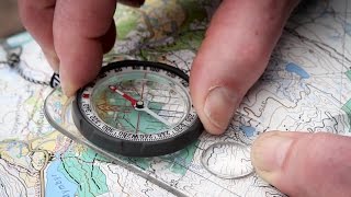
Having fixed your position at a particular grid reference on your map and having discerned the difference between your orienting lines and your orienting arrow on your compass, where is that you wish to go and how might you get there? Are you looking for a sunny spot out of the wind for a lunch break, or trying to find your way back to your car or tent? Either way, you need an objective or target location to navigate toward from your current position. Firstly, set your map - 'setting the map' simply means having it pointing the right way - and have a look around. Note the features - paths, roads, walls, rivers, power lines, buildings - that are defined on your map and that you can see. The simplest way to achieve your objective from your location would be to find a path linking the two points and to follow it! Similarly, having set your map in fine weather, the surrounding features and terrain variation can be easily identifiable from ground to map and vice versa. Picking out the features that you can actually see from where you are and that you will then see en route to your target and then walking between them is another method to get you where you wish to go. Mentally ticking off each feature you pass as you go will keep you on course. But what if you cannot see your target; if the target is on the other side of a hill, or if the weather has turned nasty, or if you are in the dark? Taking a bearing accurately and accurately walking along it will allow you to progress from your location to your objective even in the worst fog or a blizzard or at night. There are a number of ways to describe the same process and nobody has released a video that, to my mind, nails it completely. Hence, the three different takes on the same subject from eminent experts as published by the likes of the BMC, Ordnance Survey, Glenmore Lodge - Scotland's National Mountain Training Centre. We begin with a return to the beard, Chris Townsend ... ... before giving Steve Backshall a go ... ... and then walking a bearing with Glenmore Lodge ... Some of the terminology used - 'aiming off', 'catching features', 'contours', and 'magnetic variation' aka 'declination' - is a bit more advanced and the subject for another set of posts. For now we will concentrate upon the basic principles and leave practical application for another day. Silva, the compass manufacturer, released a video showing the practical value of the subjects covered so far in use in the field. It is a bit longer and has a cheesy voice-over but it's well worth a watch as it provides a high-level overview of the navigation basics that you actually need know when it comes to getting around the hills safely. Bearing setting using the 'Silva 1-2-3 system', described at 2:42, has proven a useful way for many to remember how to take a bearing quickly and easily. #Navigation #Maps #bearings #eastings #northings #locationfinding #gridref #topography
- 'we the globe can compass soon ...'
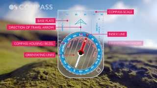
Very simple things are compasses, not at all like Shakespeare's plays, a bit of plastic with a needle that always points north. Really, that's about the size of it. Needle. North. Pointedly not when located next to your smartphone or leatherman though, they make strange bedfellows. It's the what you have to do with your compass that gets a bit tricky, especially when the pressure is on. And yet, as with most things, practice makes perfect, getting it out of your bag and using it often, even when you don't need to, is the key to staying not lost. How you wield your compass in anger depends upon the task in hand and these tasks we will come to in subsequent posts. Before we get to the how though, it seems sensible to run through the what. What are features making up a simple baseplate compass, such that you should have in your bag with your map before heading out? So, compass in hand, what are those arrow things and why are there ruler type things on it? Step forward Steve Backshall, again!, here he runs through the features found on a baseplate compass at the Ordnance Survey's behest. If you don't have a compass then borrow one and familiarise yourself with it, or better still buy one for yourself. In terms of the myriad outdoor gear available, a compass will easily provide the most bang for buck of anything you might buy. It might even save your life one day, put a price on that! There are many compass manufacturers out there and of these the Silva Mk4 is the one you will find in my bag, or rather the two you will find in my bag. I always carry a spare because I'm both a bit absent minded and a bit clumsy sometimes! Here the folks from Glenmore Lodge take a look at the features of a Silva Mk4. The background to mapping a reference point and establishing a grid reference, the key to knowing where you are, were covered in earlier blog posts. Knowing now all about the tool required to navigate about the landscape safely; it follows that you are going to go somewhere else . The process for establishing where the next place you want to go to, your target, is relative to where you are currently standing is known as 'taking a bearing' and we will cover that next. The art of knowing where you are going and how to get there, or where you have come from and how to get back there, relates to all the good stuff about navigation that can be found in our other blog posts. See you out on the hill sometime. #Navigation #Maps #bearings #locationfinding #compass #gridref
- what on earth is an easting?
There are loads of different types of maps but each has one thing in common: They all have grid of squares overlying the topographical features being mapped in any given location. We will focus on the Ordnance Survey of Great Britain's maps and their British Grid (BG) system, where each square drawn in blue lines (the map's grid) represents a one square kilometre area. The map's grid lines clearly run top to bottom, these are the 'eastings' because they divide the map vertically and moving from one to the other would mean moving eastwards or westwards. Similarly, the grid lines running from side to side are the 'northings' because they divide the map horizontally and moving from one to the other would mean moving northwards or southwards. Both sets of lines have numbers in matching blue type next to them at the edge of the map. After reading about Grid References earlier, we know we need these numbers to locate ourselves, but how do you remember which ones are which and which come first in a grid reference e.g. TL 625 333? One way to think about it is alphabetically, E comes before N in the English alphabet and so we quote the easting numbers before the northing numbers. Another way is to use the delightful old mnemonic phrase describing a child going to bed, whereby they go 'along the corridor' before going 'up the stairs' to their room. Whichever way you come to remember your easting from your northing, the order in which you quote grid reference numbers is critical. Determining a grid reference Here you can watch as the Ordnance Survey has Steve Backshall take you through the process of determining a 4 digit grid reference, explaining the easting from the northing along the way. Origins of use The term 'northing' was first recorded as used by Isaac Hayes addressing the New York Geographical & Statistical Society in 1861 and its implied derivative 'easting' followed shortly after. Both have been in use since, but why? Simply because it proved a clear way to describe a concept common to all mapping applications. A British Grid grid reference* is given by a combination of letters and number pairs or, more commonly for mountaineers, triples e.g. TL 625 333. The letters denote the general area that your map sheet covers, and the numbers are used to denote a more precise location within that area. It is imperative that the order in which the numbers are plotted and then communicated is the correct way around. Get your eastings and northings mixed up and you can be thought to be tens of kilometers away from where you really are. Thankfully, when working the British Grid with its two-letter prefix it at least denotes which bit of the country you are in. So, we always quote our British Grid sheet letters (e.g. TL) and ALWAYS run along the corridor (e.g. eastings 625) before heading up the stairs (e.g. northings 333). Always. That's always always and not the sometimes always that happens after a few pints. Got it? Good. Practical Use and Scale It may prove useful to think of a grid reference's eastings and northings in terms of getting to work. If you work in The Gherkin, in London, then TQ 33 80 will be the area of the city you commute to, as it defines a 1km x 1km square, whilst TQ 333 812 defines the smaller 100m x 100m square where your office building is, and the most precise TQ 33308 81254 gives the point reference of your desk! As an aide-memoire, if in your given grid reference there are: no digits: the Grid Reference is the whole 100km x 100km square 2 digits: the Easting and Northing are each in units of 10km; 4 digits: the Easting and Northing are each in units of 1km; 6 digits: the Easting and Northing are each in units of 100m; 8 digits: the Easting and Northing are each in units of 10m; 10 digits: the Easting and Northing are each in units of 1m. The final word goes to Backshall determining the eastings and northings making up a 6 figure grid reference ... You know where you are. You can tell me where you are. Awesome! Now where you are going and how do you get there? Have a gander at the 'compasses' and 'bearings' blog posts :) *other grid references are used around the world! However; for our ease and consistency we'll stick with British Grid format and ignore UTM and the rest for now. It is enough to know that the same 'easting first, northing second' principle applies equally to any map grid notation around the world. #Navigation #Maps #gridref #locationfinding #bearings #compass #topography #easting #northing
- why are there squares on maps?
Maps come in varying sizes, usually too large and doing its best to rip itself from your hands on a windy day, and they come in varying scales, usually giving seemingly insufficient detail or confusingly too much. Nevertheless what all maps have in common is a printed overlay of squares, the 'grid', each containing the detail being mapped for one square kilometre on a typical hiking map. Here, Chris Townsend from the British Mountaineering Council will take you through the practicalities of establishing a 'grid reference' from a map should you need to work out or share an exact location. History Maps have been in use in the UK for political, military, or other uses for centuries and they became quite the fashionable thing in Victorian times, with all kinds of public agencies and private individuals producing their own to various levels of detail and scales. The 1-inch to 3-inch chains scale being one of the most widely used*. It was as late as 1919 when a seminal thought occurred 'a National Grid should be superimposed on all large scale plans and on smaller scale maps, to provide one reference system for the maps of the whole country' and the first practical steps were taken by the Ordnance Survey to provide one version of the truth for the whole of Great Britain and its territorial waters. The current 'British Grid' (BG) was the result. Using the Squares At their largest the BG grid squares have sides representing 500km and each is assigned a letter running from A to Z, but missing out the letter I. This has the twin benefits of avoiding potential confusion with the number 1 and of neatly making 25 grid squares in a 5 x 5 layout. A genius move making things very much the easier to deal with, imagine the faff of having 26 squares in this and the subsequent sub-division. Each 500km grid square is sub-divided into smaller squares with sides 100km that are themselves each given a letter for identification and used sequentially together with the 500km letter to define an area. Not all of the 100km squares are of practical use for 'topography' (a map of physical features of an area) because there is nothing there but sea. Take a look at grid squares NE and TB on the diagram, nothing but sea to see there. OK so there might be a small island in there somewhere but it is hardly going to be big seller for the Ordnance Survey to produce a map for it, so they don't. The Admiralty's charts department does however, should you be so inclined toward messing around in boats. So far so good should you wish to know where Cornwall sits in the British Grid (Grid Reference: SW), but further detail is required for practical use by mountaineers. Zooming In Accordingly, the 100km lettered squares - NH, SW, TL etc. - are broken down into 10 intervals each denoting a square with a side of 10km. These are assigned numbers 0 - 9, rather than letters, in order that a point of reference could be given clearly by a combination of letters and numbers. Diagram D shows the 'two digit Grid Reference' TL63 and it refers to a 100 square kilometre area of Essex lying East of Saffron Walden and South of Haverhill. Not of much use to a person on foot! Helpfully, the grid can be further sub-divided by 10 again. Diagram E's light blue shaded square has a '4 digit Grid Reference' of TL 62 33. It relates to 1 square kilometre area NNE of the village of Thaxted containing fields and a wood. This level of detail may be sufficient to indicate a general location for a meeting point, but are you North or South of the woods? If you wished to indicate a more precise location then the grid can be sub-divided down again to 10m and again to 1m intervals. Diagram E shows both our TL 62 33 area of fields and woods highlighted, plus another smaller dark blue shaded square with a '6 digit Grid Reference' of TL 625 333 within it. This 6 digit grid reference is 'to the nearest 100m' level of detail and is about as accurate as one can be with an ordinary map and compass. TL 625 333 would place you on the southern boundary fence of the wood, north of a place called Spriggs and 100m east of the footpath. Informing someone of this 6 digit level of detail would make you much easier to find. Even greater detail is, of course, possible. An 8 digit grid reference 'to the nearest 10m' can guessed at or be found with smaller scale orienteering maps and with electronic GPS equipment (below this their inherent accuracy tolerances will not currently go despite what it says on the screen). 10 digit grid references go further still, to the nearest 1m, as is possible with the tiny scale survey maps used by the Land Registry and local councils. Why are there squares on a map? The answer to the question then is that the squares on a map allow a method by which you can pinpoint your location. It follows that small 'features' - summits, crags, rivers and bridges, pubs - can be found on a mountaineering map, for which a '6 digit British Grid Reference' can be determined, and these can be shared if you need to meet somebody or have somebody meet (rescue!) you anywhere in Great Britain. and we're done :) Or are we? Knowing where you are is only the beginning. Knowing where you are going and how to get there, or where you have come from and how to get back there, relates to all the good stuff about 'compasses' and 'bearings' that can be found in our other blog posts. See you out on the hill sometime. #Navigation #Maps #history #gridref #locationfinding #compass #bearings #topography
- Dave's favourite mountain
Thinking skywards I remember the foothills of the Himalaya where I lived in my late teens, far higher than I have ever ventured since, I remember the hot and sticky journeys and being scared senseless by the terrible driving and the wrecks of colourful trucks strewn across the subtropical jungle. One night I was taken in an impossibly old Land Rover by a Gurkha friend to Tiger Point a place to see Kangchenjunga at day break, a turning point in my young life. There is also my failed attempt up the highest mountain in the Dolomites, Marmolada. I was following my friend, cousin and now leader of City Mountaineering up the great glacier that leans across the mountain before (sensibly) turning back when the clouds came in and things got sticky. A truly magnificent beast of a hill and one I would like to befriend again. But those memories are from other places, visits in another world. My favourite mountain would have to be within the country that I grew up, the wet, windy and sometimes rather chilly world of Britain that is my home. There are days on a hill on this island when looking around all you can see are green hills and blue sky with a cool wind brushing over you, on those days there is nowhere better to be. So, my favourite mountain could be: the Old Man of Coniston which I climbed one snowy New Year’s Day just after my first son was born, it was completely covered in snow and what fun we had; or it could be Blencathra, the hill that I think looks like a lion sleeping with its ridges protruding in all directions; or maybe Cnict aka the 'Welsh Matterhorn', it's a stunner of a hill away from the masses that has bags of character. But in truth it is none of these. When I was a young boy I was entranced by J.R.R. Tolkien and C.S. Lewis and I am happy to admit that in the 90’s I spent much time with my friends role-playing Dungeons and dragons and painting games workshop lead figures. In these worlds of elves, dwarves and great legend Dragons sat on top of mountains that were so sharp that you knew they could never exist. But then one day when I was thirty years old my friend took me to see Tryfan and although he told me otherwise I knew that this was my mountain and I knew there was a dragon at the top. #Favourites #Kangchenjunga #Himalaya #Marmolada #Dolomites #OldManofConiston #Cnicht #Tryfan #Blencathra
- The Scotland Adventure - Part 2
“Thousands of tired, nerve-shaken, over-civilised people are beginning to find out going to the mountains is going home; that wilderness is a necessity” - John Muir Continued from Part 1... After the fabulous day out on Liathach, I spent time in the valley with Ewan and his family for a few days of Rest & Relaxation, away from the hustle and bustle of London-life. But, Christmas was approaching and they had to head south to their extended families while I, being me, decided to head north... A Wild Christmas Bidding farewell to old friends is always tough, especially those that live in distant lands, but the goodbyes are as inevitable as the hellos and move on we must... Ewan and family headed south for Christmas and I... Well... I didn't... Using the North Coast 500 route as a loose plan of direction, I was on my way back to one of my favourite places in The UK - Assynt. And, as an added bonus, it was winter, so I practically had the place to myself (plus a few locals, and sheep, and deer, and cows) I still hadn't decided where I was going to spend my night on Christmas eve and realised that "if I didn't know where I was going to be, then how would santa!?" Finally coming to accept that santa would not be delivering anything to me this year, I continued on my aimless merry way further and further north. I'd elected for isolation over Christmas. A time to chill out and reflect on what had been an incredibly hectic, but amazing year of adventure. I therefore decided to head to a bothy for some peace and quiet. I had intended to visit the far north-west coast, but with the rivers in spate (and a lifetime reluctance to retrace my steps to an easier route) I couldn't get over the torrent of water so I pressed on, around the north coast, to Kyle of Tongue and views of mountains and sea that are simply breathtaking. The Bothy I packed a small bag with the essentials for a couple of nights in a bothy - sleeping bag and wine (and mince pies - it was Christmas, after all) and I made my way across the boggy landscape to my home for Christmas. Arriving at 2pm, I collected wood and fed the fire to warm up this isolated stone hut, then happily boiled water for tea and dinner, started on a book that I had been meaning to read all year (did I mention how busy I'd been in 2018?) and simply relaxed into my environment. By 4:30pm there is no more light offered by the sun and the darkness comes alive with it's stillness. Standing outside in pure silence and pure darkness shuts down your sight and opens all your other senses - the smell of the fresh air, the sound of your breath and the feel of your heart beating. It was good to be alive. By 8pm, I relaxed even further... For once, I had the entire place to myself! Pure bliss! Tired and weary, I decided to call it a night (yes, I felt like a 90-yr old going to bed so early). I dampened the fire, switch off the head torch, crawled into my sleeping bag and drifted off into a deep sleep... Then, suddenly, there was a loud noise and light passing the window! I woke instantly... Where am I? What time is it? What the hell is going on? Unexpected guests What happened next was blurry but excruciating... It was 10:30pm and a family of 5 had decided that they wanted to have a "Wild Christmas" and, as [bad] luck would have it, they chose MY bothy to spend their time this Christmas! If you have never spent a night in a bothy, I'll explain the thought process as you approach and settle in to the hut: 1. On approach - 'I hope no one else is there' 2. Upon seeing the bothy - 'I can't see smoke and I can't see anyone. It's looking good' 3. Upon reaching the bothy - creep inside and search the entire hut for signs of other people 4. In the bothy - 'I hope no one else turns up' 5. Going to bed - 'Yes! we have it to ourselves!' Remember, this was Christmas eve. Other than me, who else would turn up to a bothy so late on the day before Christmas! Clearly, this loud family of 5 would... Did they see me sleeping? - Yes Did I acknowledge them? - No (This was my biggest mistake!) Having woken up suddenly and after an afternoon of calm relaxation, I didn't really want to converse with anyone (note: to anyone joining a City Mountaineering trip, it's best not to approach me until I've had my first coffee :) My thoughts were that they had arrived late and would therefore head straight to bed, readying themselves for Christmas the next day. I was wrong. Did they quietly move into the other room, so not to disturb the sleeper? - No, no they did not! I had spent all afternoon warming the room that I was in, why would they move into the larger, colder room? But, it was nearly 11pm, surely they will just go to sleep and enjoy their glorious surroundings in the morning! - Nope! The entire group went upstairs, changed into their pyjamas and returned to my room, cans of beer were opened and the fire was stoked. The conversation got louder and louder, discussing the same thing over and over and over again... I can, even now, recite what each of them had carried in, what they were looking forward to for Christmas dinner and what they had forgotten to pick up (they were all really looking forward to the cheese, by the way) A Sweaty Christmas I think I should add, at this point, that the sleeping bag I used for the Scotland trip was my expedition, high altitude bag. I didn't have space for options, and was fully expecting a bitterly cold winter and hoped to wild camp for most of it. This sleeping bag is rated to -30 degrees... By 2am, a couple of them had gone to bed, while the others continued to chat merrily, with no regard to the sleeper in the corner (I wasn't sleeping, but time had gone too far for me to just get up and walk out). They continued to stoke the fire to proportions that could only be compared to the temperature of the sun! Why didn't I just acknowledge them when they arrived and simply moved to the colder room? By this time I had probably lost half of my body weight in sweat and was hoping that I would soon go unconscious from either dehydration or hyperthermia - if only to save me from the chat! At 3am, the final family members decided to call it a night and went to bed. I jumped out of bed, downed 2-litres of water and wafted my sleeping bag to cool myself down. I then dampened the fire before crawling back into my soaking wet sleeping bag and finally drifted off, back to sleep. My solo bothy night of rest and relaxation was ruined. In the morning I heard the family start moving around upstairs. I felt like I'd already outstayed my welcome and didn't fancy Christmas small talk, so I packed my bag and left in silence. Onwards, I hiked, to a mountain that I'd never climbed, but had been in my sights for many, many years. #Winterhiking #Mountaineering #Mountainbenefits #Mountainweather #Bothying
- The Scotland Adventure - Part 1
“To live is the rarest thing in the world. Most people exist. That is all” - Oscar Wilde I am finally getting time to breathe after what has been one of the best starts to the year ever! That said, the full adventure actually started on 27 November 2017, when I decided that I would pack my bags and leave London to spend the winter in snowy Scotland. So, without any further thought, I threw my bags into the car and set off that very same day... I had a general plan [to winter in Scotland] but the specifics would be decided on a day-to-day basis... And so it began... Organising the diary I was keen to share my adventures with City Mountaineering folk, so I organised weekend trips around my general whereabouts throughout the winter. Long overdue visits to friends in the midlands and the north of England ensued, before I reached The Lake District and a weekend of scrambling fun with City Mountaineering. I continued north, visiting more friends in the Scottish borders before meeting the next City Mountaineering group in Glasgow and whisking them away to Fort William for a scramble ascent of Ben Nevis, via it's gnarly north face. However, there was a problem... Winter had arrived early! With Ben Nevis in full winter conditions, the trip turned in to an "Introduction to Winter Hiking" - Fully equipped with ice axes and crampons, the group had a bonus of trying this incredibly rewarding activity in conditions they wouldn't ordinarily consider. And what stunning weather we had, too! Next up, I had planned to meet the next group of friends in Glen Coe, followed by a few days in a beautiful cottage on the shores of Loch Torridon. With the fresh snow came the first unplanned activities of the year... Skiing in Glen Coe before Christmas (who would've predicted that! - Well, the guy at the Old Dungeon Ghyll pub, evidently - see previous blog) and a winter traverse of Liathach. The following is the musings of Stuart (founder of City Mountaineering) and an insight in to what he enjoys doing when not leading groups in the mountains. As you may expect, his holidays involve mountain adventures... "These events would never happen on a City Mountaineering trip because every trip is planned to the finest of detail. City Mountaineering was setup for others to have their own adventures in the mountains, not me (it would be irresponsible of me to push my own adventure agenda whilst looking after others!). Having criss-crossed the UK mountains so many times and, nowadays, having a duty of care and responsibility over a group, I rarely get the chance to go on these types of adventures anymore. But when I do - Oh my word, they are awesome!" - Stuart, founder of City Mountaineering Liathach Liathach is a grand and ancient lump of rock, acting like a guard to anyone entering the Torridon area of the highlands. It can be seen from miles around and is on many a mountaineering tick list! My friend, Ewan, and I got up early and drove the short distance to the car park, before making our way to the foot of the hill. We had no plan of ascent/descent - All we set out to do was traverse the ridge - We would decide which route we would take on and off the lump when we got there. On the approach we saw a great snow/ice line in a large gully and, without guide book (we intentionally wanted to 'freestyle' the day), we made our way into the gully and, donning harnesses, ice axes and crampons, we roped together and made our way into the gully. With cathedral height walls either side of us, we were in a committing, but manageable, position. It was either up or down from this point. The sun was soon to rise and snow was soft and deep, but had consolidated well enough for us to proceed. The going was tough in the deep snow, but we continued regardless to an icy step. It didn't look ideal; with what looked like great water ice from below, turned out to be a thin layer of horrid rhyme ice. We had a choice: Climb the rhyme, descend and find another route, or climb the rock to our left/right. We climb in the summer and our original intention was to 'play on the ice' so we decided to fix an anchor and proceed on the rhyme... Me first, leading the way. Or, as it turned out, cleaning the route! The rhyme was thin and brittle (well, is it rhyme, after all!) as I climbed the first 3-metres and reached an impasse. I was standing with just the front points of my crampons just a couple of millimetres into the ice on a bulging rock with nothing beyond the bulge in which to get purchase and my delicately tapping axes searching for something to grip. I was stood there for too long. Surely the thin ice under my feet wouldn't hold for much longer. And sure enough, it finally gave way! I had placed one axe in a decent crack ("decent" is a relative term we use in these situations... In this case it meant "the ice axe was twisted in a tiny, flaky rock crack to create a cam effect in anchoring me to the block"). My other axe was then used to find anything! a small hole in the rock, some "good" ice, some frozen turf!? Anything! - There was nothing (or, so it seemed) and with one final swish of the axe, my foot slipped and I was flying backwards through the air. This was poor form, indeed. As I fell through the air in slow motion I looked across to Ewan, who was rapidly taking in the slack rope and I even had time to look at my landing, which, as it happened, was a soft, deep area of snow in the gully that we had just climbed. With a textbook landing, akin to an Olympic gymnast (Ewan's words, not mine), I stood firm with none of the 'side effects' many climbers experience with such a fall (i.e. I could still walk!). Ewan offered to lead. I said no! Back on the bulge I went. This time being more committing and less cautious. I found some tiny edges to sit the pick of my ice axes and precariously walked up the bulge until I was standing on top. Success! Now all I had to do was tackle the narrow waterfall and crumbling rocks and I would arrive on the deep snow of the upper gully. This went without incident and I rushed higher to setup an anchor for Ewan to follow on... A quick bucket seat dug in the snow and finding backup protection from a couple of fallen icicles ("bomb-proof" I say... Ewan says otherwise...), Ewan was with me in no time and proceeding up the gully to the ridge of Laithach. We made our way along this mighty fine ridge in good time and picked our route down. We could head down the standard slope, back to the car, or we could head down another gully. Of course we picked the gully! "Let's hope it doesn't steepen further down"... We descended in to the broad, y-shaped gully, caused by two streams descending and meeting before gorging its way down the mountainside. The going was easy on soft, deep snow (again!) and the slope was steep, so we sat down and slid our way off the hill, using our ice axes as a rudder and braking device. Ewan, now 20-metres ahead of me, shouted back with a warning to "watch out for the hole" - I passed it on the left, glancing down as I glissaded faster and faster down the gully. The hole was HUGE! - We were sliding down 8ft deep snow that was sat 2ft above the fast flowing stream below. We continued on for another 200m before I saw Ewan stop and stand up. 'It must be another hole', I thought. I then saw Ewan leap. 'yes, it's definitely another hole', I thought Then Ewan disappeared! 'where has Ewan gone?', I thought. I rushed down to see what had happened and found a large hole ('yes, it was another hole' I thought) and, about 1-metre beyond the hole was another, smaller, Ewan-shaped hole in the snow. 'Shit! I hope he's ok!', I should've thought. I laughed. "Mate! are you ok?", I shouted (trying to conceal my laughter). No response. Ok, this could be serious. I continued to shout with no response, until I heard a faint "Can you throw me the rope?". Phew! "No probs, are you ok?". "yeah, I'm fine, but I'm stuck in 10ft deep snow cave getting wet in the stream". I laughed. I never thought I'd ever have to set-up a crevasse rescue system in The UK, but that I did (insofar as I hauled him as he climbed his way out of a soggy hole). Retrieved from the hole, we decided that we would avoid the gully for the rest of the descent and chose to descend the rocky ridge-line instead. Safely returning to the road under torch-light, we hiked back to the car and returned home with thoughts of potential epics, the what-ifs and the maybes. In all seriousness, we were always fine and we always had each other's back. The landing from a potential fall at the start was always calculated in the risk we were taking and the icicle anchor was setup to get a reaction from Ewan (the bucket seat was awesome! :) But, it's adventures like these - those with capable mountaineering friends, which are unplanned and unforeseen - that I love so much. This micro-adventure saw me to Christmas and, with the next City Mountaineering trip 2-weeks away, I had time to wander... And wander I did... Next Up... A Scotland Adventure - Part 2 #Winterhiking #Mountaineering #Mountainbenefits #Mountainweather #Torridon
- A couple of Ben's; The good and The bad
“Does anybody really think that they didn't get what they had because they didn't have the talent or the strength or the endurance or the commitment” ― Nelson Mandela City Mountaineering So, I’ve been trying to do as much training as I can. I can’t expect to hike up to 6,000m on a mountain without putting in the effort to be as fit as I can be. That said, The only way to really train for hiking up a mountain, is by going up mountains. So, I thought there must be some London hiking groups going further afield and actually hiking up mountains in the UK without having to go abroad! It is then I found City Mountaineering. The description of City Mountaineering trips was just what you needed: - Where you had to meet and what time; - What you were going to be doing; - The level of fitness needed; - When we were due back in London, and; - The price, which was reasonable Even the accommodation and food was sorted for us! My eyes stopped onto one particular weekend trip: The Winter ascent of Ben Lomond. Reading it made travelling to Scotland, summiting 2 mountains all in the space of a weekend without taking time off work so easy. I was in. My first time going to Scotland was arranged. The Travel Clear, precise, instructions were emailed through. Kit list was detailed, which luckily I had from Gran Paradiso and any other information that was needed was there. We were to meet a guy in Euston train station at 6pm and, me being me, of course, got there 45 minutes early and, over the next hour, the rest of the group turned up and off we went. London Euston to Glasgow. 4.5 hours passed and we arrived. Stuart (the Mountain Leader) met us at the station, packed our luggage into the minibus, introductions were made and a swift exit to the hostel was underway. An early departure was planned to drive to the Trossachs National Park, so a brief explanation was given and off to bed we all went The Hiking - Day 1 Dressed prepared for hiking, we all made sure we had everything ready, the hiking rucksack packed with the lunch and snacks made for us by Stuart and water bottles filled. It was a hour drive to the national park. Tuition was given about the crampons and ice axe which made me feel more at ease and even more ready to use them again. Hiking began. I remember feeling so happy that I decided to join City Mountaineering to come to Scotland and hike. The whole way up, I was completely blown away by the beauty that surrounded me. Gorgeous blue skies, beautiful sunshine, clear, turquoise lakes in the distance and snow covered terrain. I was experiencing my version of heaven on Earth. At times, it was actually quite emotional. I felt so lucky to be alive and here. Stuart, was such a good mountain leader. When the snow was waist deep, he would create a path so it was much easier to walk though. Going up quite steep elevation, he would kick steps into the ice which would make it much less of a physical and mental challenge, also, he knew, traversing up in a zig zag with my right side facing the mountain was hard for me, physically, because of having the axe in my left arm, he would make sure I was ok without singling me out. The summit was reached! I could have stayed there forever. It was absolutely glorious. The task of getting up there melted away. I could have flown up. I forgot the difficulties I had, how at times, the physicity that was needed, it didn’t matter. It was, incredible! As we were coming down the sun was setting. Everyone had this glorious glow about them. You could tell how happy everyone was. We got back to the hut, showered, ate and rested our hiking legs. The Hiking - Day 2 Ready to hike again. This time, Ben Narnain. In our hiking attire, bags packed into the minibus and off we went. An hours drive to this mountain. Snow was in the air. Stuart mentioned that the first part of this hike was much like a public path until we got through the tree line. After yesterday, we were all quite glad of the easier start. Crampons were put on much earlier as the path was quite icy because of the amount of snow that they have has recently. Stuart had warned us that that a snowy front could happen while on the mountain. It did. Again, waist deep snow which Stuart was clearing as much as he could for us out in front. Sideways, 35 mph snow that was like having your face exfoliated. We all had the same agenda in mind. Reaching the summit. It was getting heavier. A complete white out where you couldn’t see much ahead of you apart from Stuart’s feet and the path he was making. Everything was white. The sky was the same colour as the the ground. I remember on days like this, in the Alps, not skiing and staying inside but no going back now. Head down, single file, we made it to the summit. Quick picture of our achievement and back down we went. Because of the amount of snow that had fallen so quickly, Stuart was slightly ahead making sure that the path he was taking was suitable and safe. As we we were coming down, because of the height of snow that was forming and having to lift your leg high over it, I was starting to get pain in my right hip to the point where I was in tears. Now I’m not a crier but this pain from the repetitive movement was becoming excruciating. I knew that the only time that this pain was going to subside was when we were back on the path. So I accepted it and carried on. It was becoming clearer and the path could be seen in the distance. A warm internal hug wrapped round my heart. I was so happy. My pace became quicker and I walked ahead of the group. As I was walking down the path, near the end, in front was a reindeer. Such a beautiful, peaceful animal. I was as quiet as I could be and watched him for ages. Gone was the pain from my hip. I took his being there as congratulating our success. Back to the van and off to the train station. Into the train we all got with enough time to get out of our hiking gear. A well deserved 4 hour journey, sat in the warm, back into London. Memorable Micro-Adventures Who knew that a trip to Scotland and completion of 2 mountains of completely varied weather could be done in a weekend. Thanks to Stuart and City Mountaineering it’s very possible. Being away, feeling completely supported and meeting like minded people was the best way to start 2018. I will definitely be going away with City Mountaineering again. This weekend allowed me to see that my training was paying off. Minimising socialising and life ‘normalities’, even though, at times, really test my mentality, I just need to keep believing it is all worth it. Again, I would have not recovered after my accident like I have if I hadn’t put everything into my fitness and recovery. If you want something bad enough, go in whole heartedly with the belief that things will get better and work your hardest for it. #Mountainbenefits #Winterhiking #Whiteout #Mountaintraining #Mentalstrength